Перейти к основному содержанию

page search

Displaying 133 - 144 of 2317

Oran : des terres agricoles sacrifiées pour un urbanisme sauvage

Peer-reviewed publication
февраля, 2021
Algérie

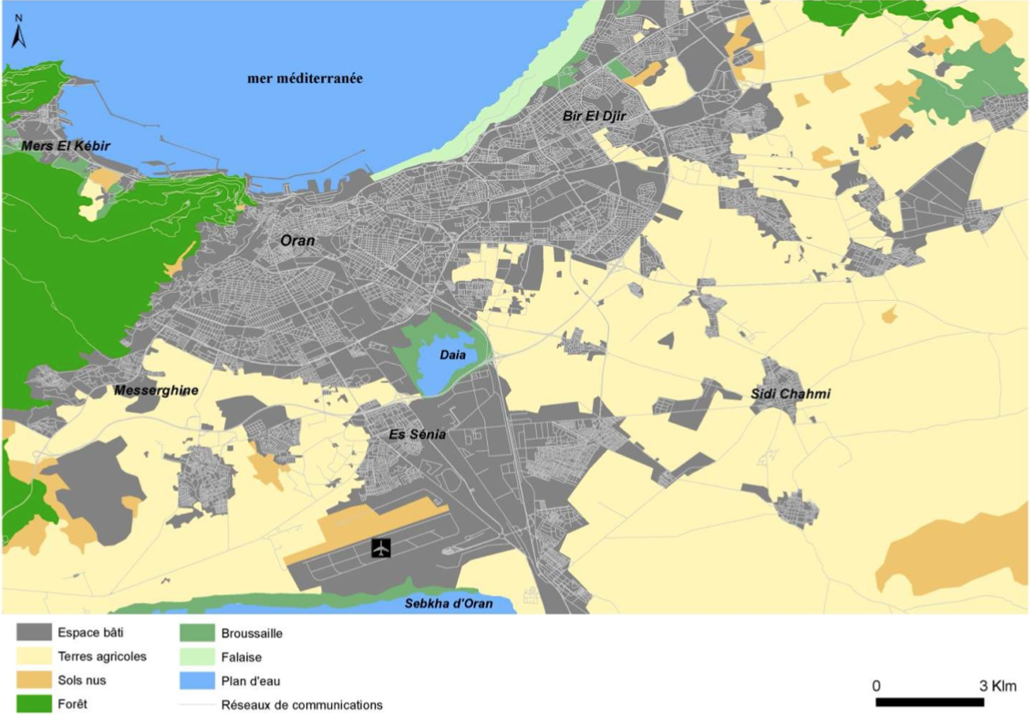
Aujourd’hui, la périurbanisation est reconnue comme un phénomène mondial animée par différents déterminants (poussée démographique, développement industriel, crise de la ruralité, etc.). En effet, les territoires périurbains sont des espaces qui reçoivent l’excédent de la croissance démographique urbaine et qui accueillent les nouveaux projets d’aménagement et de développement (promotions immobilières, implantations de zones d’activités diverses, développement des réseaux de communication, maintien ou développement de certaines agricultures, etc.).

Expériences du quota et de l'accès collectif dans le delta de la vallée du fleuve Sénégal

Reports & Research
февраля, 2021
Sénégal

Le phénomène d’ATGE gagne l’ensemble du Sénégal, privant les communautés de leurs droits fonciers, des principaux moyens d’existance. L’IPAR, en partenariat avec le CNCR et aGter, a bénéficié d’un appui financier du CRDI pour exécuter ce projet de recherche- action participative et collaborative.

Ce projet évalue des initiatives mises en œuvre et analyse du contexte global de trois communes, situées dans trois zones agro-écologiques : bassin arachidier, Niayes et vallée du fleuve Sénégal, afin de :


What about the “Stayers”? Examining China’s Resettlement Induced by Large Reservoir Projects

Peer-reviewed publication
февраля, 2021
China

Large reservoir projects typically occupy vast lots of rural land and trigger resettlement on a massive scale. In China’s reservoir context, increasing concerns have arisen regarding distant-resettlees (those who are resettled outside the reservoir area), while fewer studies have examined the nearby-resettlees (those who are resettled near the original area) and the non-movers (those who do not resettle). The significance of these two groups has been downplayed and their populations are in the millions (or more) in China.

The Amazon Forest Preservation by Clarifying Property Rights and Potential Conflicts: How Experiments Using Fit-for-Purpose Can Help

Peer-reviewed publication
февраля, 2021
Brazil
United States of America

The burning and the deforestation of the Brazilian Amazon forest, which has been recently highlighted by the international press and occurs mostly on public or undesignated land, calls for an in-depth examination. This has traditionally been the main way to grab land, speculate, and simultaneously prove ownership by its occupation. The absence of mapping, registration, and an effective regulation of land property in Brazil, particularly in the Amazon, plays an important role in its deforestation.

The Production of Pastoral Space: Modeling Spatial Occupation of Grazing Land for Environmental Impact Assessment Using Structural Equation Modeling

Peer-reviewed publication
февраля, 2021
Mongolia

Environmental impact assessment (EIA) is a key tool for both environmental and land management. It identifies potential adverse and unintended consequences of the projects on land use and the environment and derives possible mitigation measures to address these impacts. Calculating the volume and severity of impacts is complex and often relies on selections and simplifications. Moreover, calculating impacts associated with nomadic-pastoral (dynamic) land use is still an unresolved methodological problem.

Building on “Traditional” Land Dispute Resolution Mechanisms in Rural Ghana: Adaptive or Anachronistic?

Peer-reviewed publication
января, 2021
Sub-Saharan Africa
Ghana

Despite the ongoing land administration reforms being implemented across sub-Saharan Africa (SSA), including Ghana, as a viable pathway to achieve tenure security and greater efficiency in land administration, the subject of land dispute resolution has received relatively less attention. Whereas customary tenure institutions play a central role in land administration (controlling ~80% of all land in Ghana), they remain at the fringes of the formal land dispute adjudicatory process.

Seasonal and Interannual Ground-Surface Displacement in Intact and Disturbed Tundra along the Dalton Highway on the North Slope, Alaska

Peer-reviewed publication
января, 2021
Global

Spatiotemporal variation in ground-surface displacement caused by ground freeze–thaw and thermokarst is critical information to understand changes in the permafrost ecosystem. Measurement of ground displacement, especially in the disturbed ground underlain by ice-rich permafrost, is important to estimate the rate of permafrost and carbon loss. We conducted high-precision global navigation satellite system (GNSS) positioning surveys to measure the surface displacements of tundra in northern Alaska, together with maximum thaw depth (TD) and surface moisture measurements from 2017 to 2019.

Integration of Geospatial data of UAVs in Cadastral Management System and Regularization of Illegal Occupations in Informal Settlements

Peer-reviewed publication
декабря, 2020
Africa

Abstract: To avoid illegal occupation of people in areas where construction is forbidden and the development of informal settlements, municipal authorities must anticipate city planning. The implementation of layouts and cadastral plans, plays a broad range of uses in: taxation, land development, land registration, urban planning and design of infrastructure necessary to improve the living conditions of the population. This paper aims to demonstrate that, the integration of images of Unmanned Aerial Vehicles (UAVs) is an alternative solution to the production of cadastral maps.

Housing Development, Local Land Conflicts and Sustainable Land-use Planning in Peri-urban Ghana

Peer-reviewed publication
декабря, 2020
Ghana

This paper examines the various ways local land conflicts affect sustainable land-use planning in peri-urban Ghana. In recent years, rapid urbanisation has resulted a high demand for customary lands for housing development in peri-urban areas in Ghana. Customary lands are continuously converted into housing uses; leading to eviction of indigenes from their farmlands. A mixed method approach was used to collect data from 40 participants from the research site, Aburaso.