The Community Land Act,2016

Legislation & Policies
Agosto, 2016
Quênia
THE COMMUNITY LAND ACT No. 27 of 2016
Date of Assent: 3lst August,2016
Date of Commencement : 2 I st September, 201 6
THE COMMUNITY LAND ACT No. 27 of 2016
Date of Assent: 3lst August,2016
Date of Commencement : 2 I st September, 201 6

THE FOREST CONSERVATION AND MANAGEMENT ACT, 2016 No. 34 of 2016
Date of Assent: 31st August, 2016
Date of Commencement: By Notice
Contains background to land administration in Ghana; Laudato Si and land grabbing – the Ghanaian context; unmasking land grab – case studies; empowering communities to address land grabbing in Africa – lessons from Ghana; policy considerations and recommendations.
Equitable access to land is vital for inclusive economic growth, sustainable development and food security. Much is known about the topics of land governance and food security, but it is not always clear how the two relate to each other, especially in specific country contexts. Brings together findings and outcomes from Uganda, Ghana and Ethiopia to provide policy recommendations for improved land governance and food security in Africa.

The Department achieved 56% of Q4 targets and 50% of Annual Performance Report targets in its Administration programme while annual targets on vacancies filled and disciplinary cases were partially achieved. In Geospatial and Cadastral Services, the Department achieved 77% of its Q4 targets and 69% of its APR targets. The Rural Development programme achieved 71% of its Q4 targets and 86% of its APR targets. The annual target for establishment of rural information desks was not achieved and the target of jobs created was partially achieved.
Quality information on land is crucial to making good decisions about it. Increasing access to this information is important, and it is particularly vital to get it to groups who focus on social and environmental missions. This report is about the information needs of these ‘common good land users’, the data that is available, and how to get it to them. It’s based on a series of interviews with common good land users, data producers, and other experts. We also explored the data, and tested some approaches to making it accessible at a ‘DataDive’ we ran with volunteer data scientists.
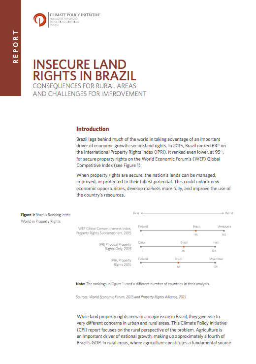
Brazil lags behind much of the world in taking advantage of an important driver of economic growth: secure land rights. In 2015, Brazil ranked 64th on the International Property Rights Index (IPRI). It ranked even lower, at 95th, for secure property rights on the World Economic Forum’s (WEF) Global Competitive Index.
When property rights are secure, the nation’s lands can be managed, improved, or protected to their fullest potential. This could unlock new economic opportunities, develop markets more fully, and improve the use of the country’s resources.
There is no world-wide common platform that stores and provides core data and information related to the assessment, monitoring and mapping of agri-food, environmental and water resources through indicators derived by the combination of remote sensing, geospatial anlysis, in-situ measurement and country reporting. The initiative aims to establish it.

Zambia’s agriculture sector provides the main support for the rural economy. This assertion is based on the fact that about forty nine percent of the Zambian population depends on agriculture, primarily through smallholder production for their livelihoods and employment (CSO, 2014). Notwithstanding this fact, in 2015 the sector contributed 8.5 percent to the GDP and approximately 9.6 percent of national export earnings (CSO, 2015; World Bank, 2016). The potential for agricultural growth in Zambia is staggering.

Food security in Uganda relies mainly on access to land and security of tenure. Land governance is marked by the contradiction between relatively progressive legislation and only partial implementation. Institutions that have to deal with land administration and land disputes, such as customary authority systems, local government, and special courts for land justice, have weakened in the last years. Women’s position with respect to land and inheritance also remains weak, both legally and in practice, undermining their livelihoods and status in society.
Cadastral mapping in Pakistan is often sketched on paper or cloth and generally falls below cartographic standards, lacking details on coordinate systems, datum and directional information of parcel lines. Survey numbers for parcel identification also lack digital interoperability. Parcel measurements and ownership information are manually recorded in multiple separate registers. The objective of this study is to leverage geospatial technology for automation, auditing and validation of present manual cadastral mapping in Pakistan.