Training manual on spatial analysis of plant diversity and distribution

Training Resources & Tools
Diciembre, 2010
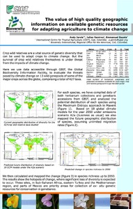
This training manual is intended for scientists and students who work with biodiversity data and are interested in developing skills to effectively carry out spatial analysis based on (free) GIS applications with a focus on diversity and ecological analyses.
These analyses offer a better understanding of spatial patterns of plant diversity and distribution, helping to improve conservation efforts. The training manual focuses on plants of interest for improving livelihoods (e.g. crops, trees and crop wild relatives) and/or those which are endangered.