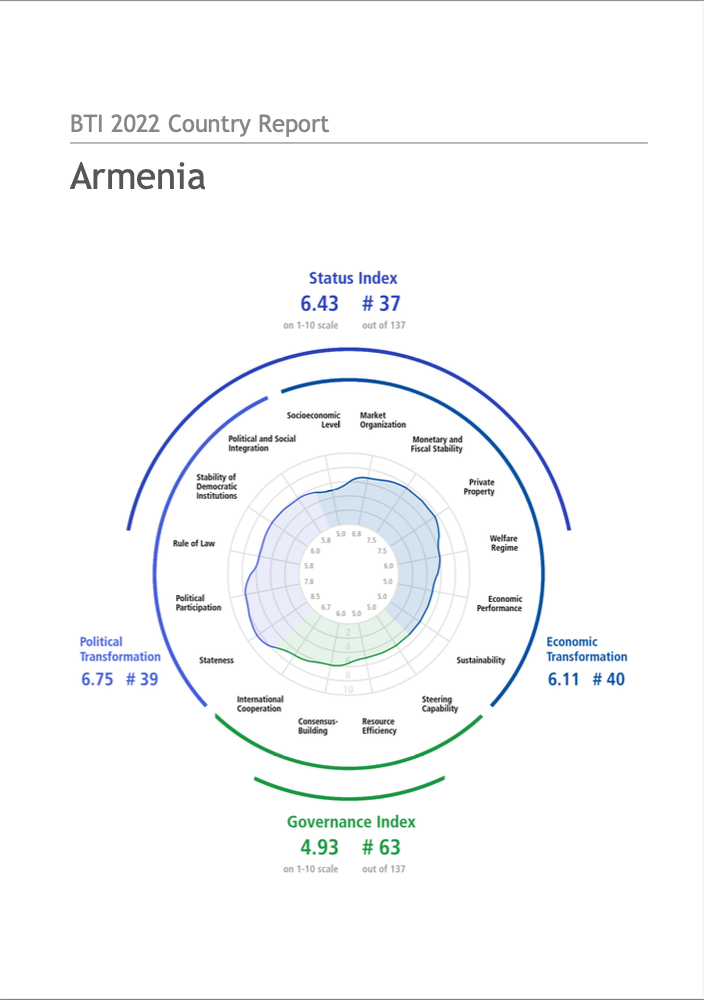
page search

Map of Armenia

Armenia

After having its independence recognised in 1991 with the breaking up of the Soviet Union, land in Armenia was quickly privatised. Despite a significant movement of the population to the countryside, as the country initially suffered from a reduced industrial output, the urban population of Armenia remains around 63% of the national total, with more than half of this urban population living in the capital Yerevan. There is continued territorial conflict with Azerbaijan over competing claims for the Nagorno–Karabakh region.
Socio-economic indicators browse all

More on this country

22 February 2023
Main photo: The Lachin Corridor has been blocked since mid-December by Azerbaijani protesters claiming to be environmental activists and seemingly acting with official Azerbaijani support. (file photo) The UN's top court has ordered Azerbaijan to allow free passage through the Lachin Corridor,…
31 December 2022
YEREVAN, Armenia (AP) — Hundreds of opposition supporters rallied in the Armenian capital on Wednesday, urging the government to act to unblock a vital road to the separatist region of Nagorno-Karabakh, after weeks of rising tension over Azerbaijani protests which choked off basic supplies to the…
25 November 2022
Azerbaijani military advances have created facts on the ground, as the two countries work on an agreement demarcating their shared border. Main photo: A new sign marks the border between Armenia's Syunik province and Azerbaijan. (Joshua Kucera) The word “borderization” is a relatively new one, but…

Armenia

projects

Euro

Euro
ISO 4217 code
EUR
Currency Symbol
13587330.09
Project duration:
to
Euro

Objectives

cities pursue integrated urban planning and implementation and increase their ambitions, to deliver impactful sustainable development outcomes with global environmental benefits (GEBs)

Other

Note: Disbursement data provided is cumulative and covers disbursement made by the project Agency.

Target Groups

657000
Project duration:
to
United States dollar

General

The aim of the FC measure is to create needs-based (agricultural) insurance solutions for the protection against extreme weather events.

1667000
Project duration:
to
United States dollar

General

Preparation of new maps and the setting up a nationwide system for efficient use of satellite technology for surveying and mapping

419710.6319
Donors:
Global Environment Facility

Euro

Euro
ISO 4217 code
EUR
Currency Symbol
13587330.09
Project duration:
to
Euro

Objectives

cities pursue integrated urban planning and implementation and increase their ambitions, to deliver impactful sustainable development outcomes with global environmental benefits (GEBs)

Other

Note: Disbursement data provided is cumulative and covers disbursement made by the project Agency.

Target Groups

657000
Project duration:
to
United States dollar

General

The aim of the FC measure is to create needs-based (agricultural) insurance solutions for the protection against extreme weather events.

1667000
Project duration:
to
United States dollar

General

Preparation of new maps and the setting up a nationwide system for efficient use of satellite technology for surveying and mapping

13587330.09
Donors:
Global Environment Facility

United States dollar

United States dollar
ISO 4217 code
USD
Currency Symbol
$
13587330.09
Project duration:
to
Euro

Objectives

cities pursue integrated urban planning and implementation and increase their ambitions, to deliver impactful sustainable development outcomes with global environmental benefits (GEBs)

Other

Note: Disbursement data provided is cumulative and covers disbursement made by the project Agency.

Target Groups

657000
Project duration:
to
United States dollar

General

The aim of the FC measure is to create needs-based (agricultural) insurance solutions for the protection against extreme weather events.

1667000
Project duration:
to
United States dollar

General

Preparation of new maps and the setting up a nationwide system for efficient use of satellite technology for surveying and mapping

2276000
Donors:
Government of Germany, German Federal Ministry for Economic Cooperation and Development

United States dollar

United States dollar
ISO 4217 code
USD
Currency Symbol
$
13587330.09
Project duration:
to
Euro

Objectives

cities pursue integrated urban planning and implementation and increase their ambitions, to deliver impactful sustainable development outcomes with global environmental benefits (GEBs)

Other

Note: Disbursement data provided is cumulative and covers disbursement made by the project Agency.

Target Groups

657000
Project duration:
to
United States dollar

General

The aim of the FC measure is to create needs-based (agricultural) insurance solutions for the protection against extreme weather events.

1667000
Project duration:
to
United States dollar

General

Preparation of new maps and the setting up a nationwide system for efficient use of satellite technology for surveying and mapping

657000
Donors:
Government of Germany, German Federal Ministry for Economic Cooperation and Development

United States dollar

United States dollar
ISO 4217 code
USD
Currency Symbol
$
13587330.09
Project duration:
to
Euro

Objectives

cities pursue integrated urban planning and implementation and increase their ambitions, to deliver impactful sustainable development outcomes with global environmental benefits (GEBs)

Other

Note: Disbursement data provided is cumulative and covers disbursement made by the project Agency.

Target Groups

657000
Project duration:
to
United States dollar

General

The aim of the FC measure is to create needs-based (agricultural) insurance solutions for the protection against extreme weather events.

1667000
Project duration:
to
United States dollar

General

Preparation of new maps and the setting up a nationwide system for efficient use of satellite technology for surveying and mapping

2200000
Donors:
European Union, Food and Agriculture Organization of the United Nations

United States dollar

United States dollar
ISO 4217 code
USD
Currency Symbol
$
13587330.09
Project duration:
to
Euro

Objectives

cities pursue integrated urban planning and implementation and increase their ambitions, to deliver impactful sustainable development outcomes with global environmental benefits (GEBs)

Other

Note: Disbursement data provided is cumulative and covers disbursement made by the project Agency.

Target Groups

657000
Project duration:
to
United States dollar

General

The aim of the FC measure is to create needs-based (agricultural) insurance solutions for the protection against extreme weather events.

1667000
Project duration:
to
United States dollar

General

Preparation of new maps and the setting up a nationwide system for efficient use of satellite technology for surveying and mapping

1667000
Donors:
Government of Norway, Norwegian Agency for Development Cooperation
  • 0
  • 1
  • 2
  • 3
  • 4
  • 5

In the Soviet era, all land in Armenia was owned by the state. Agricultural land was set up into large cooperatives and state farms. Following the break-up of the Soviet Union, a speedy period of land reform took place from 1991-1993, privatizing land and providing it to citizens free of charge.