page search

Issuesnatural disastersLandLibrary Resource
Displaying 853 - 864 of 900

National Environmental Action Plan of Estonia for 2007-2013

National Policies
February, 2007
Estonia

The National Environmental Action Plan of Estonia is a national cross-sectoral action plan of Estonia for the period 2007-2013. Its main objective is to present a consensual list of nationally prioritised activities aimed at achieving the primary goals of the environmental policy specified in the national Environmental Strategy, indicating the financing needs and discussing the most optimal use of non-budgetary funding sources.The Action Plan aims to ensure food and potable water safety.

Estonian Environmental Strategy 2030

National Policies
February, 2007
Estonia

The Estonian Environmental Strategy 2030 is a national cross-sectoral strategy of Estonia for the period 2007-2030. Its main objective is to ensure the preservation and improvement of the Estonian living and natural environment in the areas of reduction of waste, disused hazardous sites and the pollution load; sustainable use of water and mineral resources; energy; transport; forestry; fisheries; hunting; and preservation of the diversity of nature and landscapes.The Strategy aims to ensure food and potable water safety.
International Mountain Day

Institutional & promotional materials
November, 2018

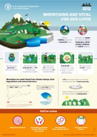
In order to celebrate the International Mountain Day and advocate for the importance of sustainable mountain development, the attached infographic will be used as a communication tool that showcases in a nutshell some of the most important facts and figure concerning mountains, their ecosystems and their communities. The infographic will highlight the IMD 2018 theme “Mountains matter” through relevant data on biodiversity, population, food insecurity, disasters etc as well as provide recommendations.

Addressing the Role of Natural Resources in Conflict and Peacebuilding

Reports & Research
September, 2015
Global

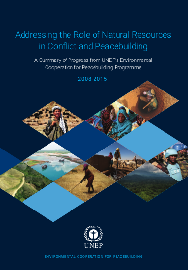
This report provides a comprehensive overview of the different outputs for each pillar and the results achieved. It also summarizes key lessons, with a future outlook for UNEP in the coming years under the ECP framework. ECP delivery partners and partnerships are also duly recognized. It also informs UNEP’s approach for address- ing con ict risks and peacebuilding opportunities from natural resources and the environment in the context of the 2030 Agenda for Sustainable Development, in- cluding the newly established Sustainable Development Goals (SDGs).

Enclosure, dispossession, and the green economy: new contours of internal displacement in Liberia and Sierra Leone?

Journal Articles & Books
May, 2017
Liberia
Sierra Leone

Through a review of recent writings in political ecology and agrarian studies, this paper appraises the potential for emerging forms of ‘green economy’ initiatives to catalyze new forms of internal displacement in West Africa, with specific emphasis on the postwar contexts of Liberia and Sierra Leone.

Agricultural landscape changes and its resilience in response to the 2011 serious floods in the urban fringe of Bangkok

Journal Articles & Books
November, 2014
Thailand

Using Bangmaenang District in the urban fringe of Bangkok Metropolitan Region in Thailand as a case study area, this study aims at examining agricultural land-use changes after the 2011 Floods with special focus on farmers' intentions of orchard use and management. Supervised image classifications were conducted for two GeoEye-1 images (before and after the floods) in order to identify agricultural land-cover changes by the floods.

Challenges and lessons learned from organizational actions by local governments for land use coordination in disaster affected rural areas of MiyagiCase of Suginoshita district and Yamamoto eastern district

Journal Articles & Books
March, 2017

This study explored local governments' efforts of land use coordination in the disaster affected rural areas of Miyagi, taking Suginoshita district and Yamamoto eastern district as a study area. Major challenges faced by the two districts are two folds. The first is the fact that multiple reconstruction projects have been implemented in parallel in one district, causing the issue of inter-program coordination.

Land consolidation in crisis management

Conference Papers & Reports
December, 2017
Poland
Latvia
Europe

Socio-economic development, public safety of local communities and environmental protection are the major pillars of the concept of sustainable development of rural areas in Europe. Land consolidation is a complex and time-consuming undertaking, which requires high expenditures, yet it plays an important role in the policy of sustainable and multi-functional development. The rapid climate change observed in recent years, resulting in a number of unusual weather conditions, has also had an effect on the directions of land consolidation development.

Volunteer group activity types of the farmland restoration after flood disaster in the northern part of Kyushu in 2012 in Yame and Ukiha City

Journal Articles & Books
March, 2015
Japan

Many farmlands were destroyed by big flood disaster in 2012 that was occurred in Yame and Ukiha city, Fukuoka prefecture at northern Kyushu, Japan. In this paper, I described the case study that has been deployed the volunteer activities for farmland restoration after the flood disaster in the hilly and mountainous areas. The purpose of this study is to clarify the outline of the activities in three regions and to show the types of the volunteer groups of farmland restoration. Interview survey was conducted with each volunteer group's manager and collecting that materials.

Historical perspectives on the future land uses of tsunami-affected areasThe case study of Hanagama District, Yamamoto, Miyagi

Journal Articles & Books
November, 2016

This study focuses on land use in the tsunami inundation area caused by the Great East Japan Earthquake, particularly land use history in the tsunami-affected area. Hanagama District, Yamamoto City, Miyagi prefecture, was selected as the study area. Land use were examined using aerial photographs taken in 1975, 2010 and 2013. Relationships between land use change and the disaster hazard areas, natural land conditions were analyzed with GIS.